Skip to content
County Tyrone — photo by Kifster
Ireland › Counties › Tyrone

County Tyrone

Tír Eoghain

Ulster · 66 places · 29 photos · 3 videos

Hero photo: Kifster · CC BY-SA 3.0

About County Tyrone

County Tyrone (; from Irish Tír Eoghain, meaning 'land of Eoghan' [tʲiːɾʲ ˈoːnʲ]) is one of the six counties of Northern Ireland, one of the nine counties of Ulster and one of the thirty-two traditional counties of Ireland. Its county town is Omagh. Adjoined to the south-west shore of Lough Neagh, the county covers an area of 1,261 square miles (3,266 km2), making it the largest of Northern Ireland's six counties by size, and the second largest county in Ulster after Donegal. With a population of 188,383 as of the 2021 census, Tyrone is the 5th most populous county in both Northern Ireland and Ulster, and the 11th most populous county on the island of Ireland. The county derives its name and general geographic location from Tír Eoghain, a Gaelic kingdom under the O'Neill dynasty which existed until the 17th century.

Intro from Wikipedia (CC BY-SA 4.0)

Explore Tyrone by category

Top 10 must-sees in Tyrone

View list page →
Sawel — photo by Kifster #1

Sawel

Sawel Mountain (from Irish Samhail Phite Méabha, meaning 'the likeness of Méabh's vulva') is the highest peak in the Sperrin Mountains, and the 8th highest in Northern Ireland. It is also the highest mountain in Northern Ireland outside of the Mourne Mountain range located in County Down.

Popularity
52
Explore place →
Ulster American Folk Park — photo by Liam Hughes from Milwaukee, WI, USA #2

Ulster American Folk Park

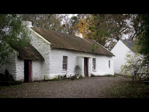
The Ulster American Folk Park is an open-air museum near Omagh, in County Tyrone, Northern Ireland. With more than 30 exhibit buildings, the museum tells the story of three centuries of Irish emigration. Using costumed guides and displays of traditional crafts, the museum focuses on those who left Ulster for America in the 18th, 19th and 20th centuries. The museum is part of National Museums Northern Ireland. Within the museum there are many restored, original buildings with connections to local families. The park was developed around the Mellon House, the birthplace of Irish-American banker and lawyer Thomas Mellon, founding father of the Mellon banking dynasty. This house and its outbuildings remain in their original location. Visitors can taste samples of traditional Irish and pioneer American foods including freshly baked soda bread and pumpkin pie all made on the hearths and griddles of the exhibit buildings. The museum also includes agricultural displays and an array of farm animals. The park is open throughout the year, excluding some public holidays.

Popularity
49
Explore place →
Mullaghcarn — photo by Gordon Dunn #3

Mullaghcarn

Mullaghcarn (from Irish Mullach Cairn, meaning 'peak of the cairns') is a mountain in the southwest Sperrins, County Tyrone, Northern Ireland. The peak reaches a height of 542 m (1778 ft), and is the 370th highest in Ireland. Mullaghcarn is in the Fermanagh and Omagh District Council area, on the edge of Gortin Glen Forest Park, and is the most southerly peak in the Sperrins. It is 5 miles (8.0 km) northeast of Omagh, and is 3.1 miles (5.0 km) south of Gortin.

Popularity
36
Explore place →
Knockmany — photo by R0025693 #4

Knockmany

Knockmany passage tomb, or Anya's Cove, is an ancient burial monument on the summit of Knockmany Hill, near the village of Augher in County Tyrone, Northern Ireland. It is the remains of a Neolithic passage tomb and its stones are decorated with rare megalithic art. They are protected by a concrete chamber and mound, built in 1959 by the then Ministry of Finance for Northern Ireland, roughly resembling the mound that would have originally covered it. The stones can be viewed through the entrance gates. It is a monument in state care.

Popularity
33
Explore place →
Wellbrook Beetling Mill — photo by Kenneth Allen #5

Wellbrook Beetling Mill

Wellbrook Beetling Mill is a restored 19th-century water-powered linen finishing mill on the Ballinderry River near Cookstown, County Tyrone, Northern Ireland. Operated by the National Trust, it is the last functioning beetling mill in the United Kingdom and is open to the public on weekends during July and August as part of a guided tour.

Popularity
26
Explore place →
Beaghmore — photo by Alun Salt #6

Beaghmore

Beaghmore is a complex of early Bronze Age megalithic features, stone circles and cairns, 8.5 miles north west of Cookstown, County Tyrone in Northern Ireland, on the south-east edge of the Sperrin Mountains. Mackay's Dictionary of Ulster Place-names says that it is from Irish an Bheitheach Mhór, meaning "big place of birch trees", a name that reflects the fact that the area was a woodland before being cleared by Neolithic farmers. Beaghmore stone circles, alignments and cairns are State Care Historic Monuments in the townland of Beaghmore, in the Cookstown District Council area, grid ref: Area of H684 842. At Beaghmore a cairn (grid ref: H6872 8470), a cairn (grid ref: H6856 8472), stone circles, alignments and cairns (grid ref: area of H684 842), round cairn with standing stones: Bradley's Cairn (grid ref: H6830 8401) and cairn and alignment (grid ref: H6863 8431), are all Scheduled Historic Monuments.

Popularity
24
Explore place →
Castlecaufield — photo by Stefan C. Kremer #8

Castlecaufield

Castle Caulfield is a large ruined house situated in Castlecaulfield, County Tyrone, Northern Ireland. The house was built for Sir Toby Caulfield between 1611 and 1619. He was granted 1,000 acres at the start of the Plantation of Ulster. This land was previously owned by the O'Donnelly family, who were closely connected to the O'Neill clan in Dungannon. The O'Donnelly fort was a few miles west of the castle. There are substantial remains. The gatehouse was rebuilt at a later date, although one of the doorways may have been reused. Castle Caulfield, today a ruin, is a State Care Historic Monument in the townland of Lisnamonaghan, in Dungannon and South Tyrone Borough Council area, at grid reference H7550 6260.

Popularity
20
Explore place →
Killymoon Castle — photo by Kenneth  Allen #9

Killymoon Castle

Killymoon Castle is a castle situated about one mile (1.6 km) south east of Cookstown, County Tyrone, Northern Ireland, on the north bank of the Ballinderry River. It is located above the Ballinderry River with a back-drop of woodland and parkland. The garden front is dominated by an almost central battlemented, machicolated round tower and turret that protrudes from the facade. At one end is an octagonal tower with similar features; and at the other end (the front) is the square tower in the base of which is arched to accommodate a porte-cochére. This tower also has slender, octagonal clasping buttresses with cupolas. The windows are pointed, grouped together under segmental hood mouldings. An 18-hole golf course was built on the parkland, where British tournaments have been played.

Popularity
19
Explore place →
Mountjoy Castle — photo by James1652 at English Wikipedia #10

Mountjoy Castle

Mountjoy Castle is a ruined fortification situated near the village of Brockagh, in Magheralamfield townland in County Tyrone, Northern Ireland, on a hill overlooking Lough Neagh. The castle played a role in the Irish Rebellion of 1641 when it was captured by the forces of Felim O'Neill of Kinard under the command of Turlough Gruama O'Quinn. The castle is a State Care Historic Monument in the Dungannon and South Tyrone Borough Council area, at grid ref: H9015 6870.

Popularity
19
Explore place →

Videos from Tyrone

CONQUERING Sawel, the TALLEST Mountain in Derry and Tyrone!

CONQUERING Sawel, the TALLEST Mountain in Derry and Tyrone!

Walkwatchers

Sawel →
Welcome to the Ulster American Folk Park

Welcome to the Ulster American Folk Park

National Museums NI

Ulster American Folk Park →
ALTINAGHREE  CASTLE DONEMANA CO. TYRONE NORTHERN IRELAND.

ALTINAGHREE CASTLE DONEMANA CO. TYRONE NORTHERN IRELAND.

Rodpiker Drone Footage UK & Ireland

Altinaghree Castle →

All places in Tyrone

Showing 24 of 66 places

Sawel — photo by Kifster▶ Video
PeakTyrone

Sawel

Sawel Mountain (from Irish Samhail Phite Méabha, meaning 'the likeness of Méabh's vulva') is the highest peak in the Sperrin Mountains, and the 8th highest in Northern Ireland. It is also the highest mountain in Northern Ireland outside of the Mourne Mountain range located in County Down.

Ulster American Folk Park — photo by Liam Hughes from Milwaukee, WI, USA▶ Video
MuseumTyrone

Ulster American Folk Park

The Ulster American Folk Park is an open-air museum near Omagh, in County Tyrone, Northern Ireland. With more than 30 exhibit buildings, the museum tells the story of three centuries of Irish emigration. Using costumed guides and displays of traditional crafts, the museum focuses on those who left Ulster for America in the 18th, 19th and 20th centuries. The museum is part of National Museums Northern Ireland. Within the museum there are many restored, original buildings with connections to local families. The park was developed around the Mellon House, the birthplace of Irish-American banker and lawyer Thomas Mellon, founding father of the Mellon banking dynasty. This house and its outbuildings remain in their original location. Visitors can taste samples of traditional Irish and pioneer American foods including freshly baked soda bread and pumpkin pie all made on the hearths and griddles of the exhibit buildings. The museum also includes agricultural displays and an array of farm animals. The park is open throughout the year, excluding some public holidays.

Mullaghcarn — photo by Gordon Dunn
PeakTyrone

Mullaghcarn

Mullaghcarn (from Irish Mullach Cairn, meaning 'peak of the cairns') is a mountain in the southwest Sperrins, County Tyrone, Northern Ireland. The peak reaches a height of 542 m (1778 ft), and is the 370th highest in Ireland. Mullaghcarn is in the Fermanagh and Omagh District Council area, on the edge of Gortin Glen Forest Park, and is the most southerly peak in the Sperrins. It is 5 miles (8.0 km) northeast of Omagh, and is 3.1 miles (5.0 km) south of Gortin.

Knockmany — photo by R0025693
MegalithTyrone

Knockmany

Knockmany passage tomb, or Anya's Cove, is an ancient burial monument on the summit of Knockmany Hill, near the village of Augher in County Tyrone, Northern Ireland. It is the remains of a Neolithic passage tomb and its stones are decorated with rare megalithic art. They are protected by a concrete chamber and mound, built in 1959 by the then Ministry of Finance for Northern Ireland, roughly resembling the mound that would have originally covered it. The stones can be viewed through the entrance gates. It is a monument in state care.

Wellbrook Beetling Mill — photo by Kenneth Allen
GeneralTyrone

Wellbrook Beetling Mill

Wellbrook Beetling Mill is a restored 19th-century water-powered linen finishing mill on the Ballinderry River near Cookstown, County Tyrone, Northern Ireland. Operated by the National Trust, it is the last functioning beetling mill in the United Kingdom and is open to the public on weekends during July and August as part of a guided tour.

Beaghmore — photo by Alun Salt
Archaeological SiteTyrone

Beaghmore

Beaghmore is a complex of early Bronze Age megalithic features, stone circles and cairns, 8.5 miles north west of Cookstown, County Tyrone in Northern Ireland, on the south-east edge of the Sperrin Mountains. Mackay's Dictionary of Ulster Place-names says that it is from Irish an Bheitheach Mhór, meaning "big place of birch trees", a name that reflects the fact that the area was a woodland before being cleared by Neolithic farmers. Beaghmore stone circles, alignments and cairns are State Care Historic Monuments in the townland of Beaghmore, in the Cookstown District Council area, grid ref: Area of H684 842. At Beaghmore a cairn (grid ref: H6872 8470), a cairn (grid ref: H6856 8472), stone circles, alignments and cairns (grid ref: area of H684 842), round cairn with standing stones: Bradley's Cairn (grid ref: H6830 8401) and cairn and alignment (grid ref: H6863 8431), are all Scheduled Historic Monuments.

Altinaghree Castle — photo by Nick W▶ Video
CastleTyrone

Altinaghree Castle

Altinaghree Castle or Liscloon House, known locally as Ogilby's Castle, is a large, derelict building situated outside Donemana, County Tyrone, Northern Ireland. It is believed to have been built around 1860 by William Ogilby.

Castlecaufield — photo by Stefan C. Kremer
CastleTyrone

Castlecaufield

Castle Caulfield is a large ruined house situated in Castlecaulfield, County Tyrone, Northern Ireland. The house was built for Sir Toby Caulfield between 1611 and 1619. He was granted 1,000 acres at the start of the Plantation of Ulster. This land was previously owned by the O'Donnelly family, who were closely connected to the O'Neill clan in Dungannon. The O'Donnelly fort was a few miles west of the castle. There are substantial remains. The gatehouse was rebuilt at a later date, although one of the doorways may have been reused. Castle Caulfield, today a ruin, is a State Care Historic Monument in the townland of Lisnamonaghan, in Dungannon and South Tyrone Borough Council area, at grid reference H7550 6260.

Killymoon Castle — photo by Kenneth  Allen
HouseTyrone

Killymoon Castle

Killymoon Castle is a castle situated about one mile (1.6 km) south east of Cookstown, County Tyrone, Northern Ireland, on the north bank of the Ballinderry River. It is located above the Ballinderry River with a back-drop of woodland and parkland. The garden front is dominated by an almost central battlemented, machicolated round tower and turret that protrudes from the facade. At one end is an octagonal tower with similar features; and at the other end (the front) is the square tower in the base of which is arched to accommodate a porte-cochére. This tower also has slender, octagonal clasping buttresses with cupolas. The windows are pointed, grouped together under segmental hood mouldings. An 18-hole golf course was built on the parkland, where British tournaments have been played.

Mountjoy Castle — photo by James1652 at English Wikipedia
RuinsTyrone

Mountjoy Castle

Mountjoy Castle is a ruined fortification situated near the village of Brockagh, in Magheralamfield townland in County Tyrone, Northern Ireland, on a hill overlooking Lough Neagh. The castle played a role in the Irish Rebellion of 1641 when it was captured by the forces of Felim O'Neill of Kinard under the command of Turlough Gruama O'Quinn. The castle is a State Care Historic Monument in the Dungannon and South Tyrone Borough Council area, at grid ref: H9015 6870.

Tullaghoge Fort — photo by Iain Crump
Archaeological SiteTyrone

Tullaghoge Fort

Tullyhogue Fort, also spelt Tullaghoge or Tullahoge (from Middle Irish Tulach Óc meaning "hill of youth" or "mound of the young warriors"), is a large mound on the outskirts of Tullyhogue village near Cookstown, County Tyrone, Northern Ireland. It has a depressed centre and is surrounded by trees. It is an ancient ceremonial site where the Chiefs of the Clan O'Neill of Tyrone were inaugurated. It is a State Care Historic Monument sited in the townland of Ballymully Glebe, in the Cookstown District Council area, at grid reference: H8250 7430. The inauguration site is a Scheduled Historic Monument at grid ref: H8251 7428.

Derg Castle — photo by Kenneth Allen
CastleTyrone

Derg Castle

Derg Castle, also called Castlederg Castle, is a post-medieval ruined fortification, situated on the north bank of the River Derg, within the town of Castlederg, in County Tyrone, Northern Ireland. It has given the town its name: 'Castlederg' derives from the Irish Caisleán na Deirge, meaning 'Castle on the Derg'. It is a Scheduled Historic Monument, administered by the Northern Ireland Department for Communities.

Parkanaur Manor House — photo by Kenneth Allen
CastleTyrone

Parkanaur Manor House

Parkanaur House is a Class A listed large Tudor Revival architecture house in the village of Castlecaulfield near Dungannon, County Tyrone, Northern Ireland. The present house is a two-storey building constructed in the 1840s from block rubble. It has a terraced front with octagonal pinnacles and gables at each projection of the façade, a big bay window and an upper oriel and incorporates an earlier two storey building as an east wing. At the rear is a coach house and free-standing office block.

CastleCaledon House
CastleTyrone

Caledon House

Caledon House, also called Caledon Castle, is a country house near the town of Caledon, County Tyrone, Northern Ireland. Caledon House sits on the private 3,000-acre woodland estate of the Earls of Caledon. For more than 200 years, the estate has been maintained as the private home of the aristocratic Alexander family.

Beaghmore Stone Circle A — photo by Wax0nightmare
MegalithTyrone

Beaghmore Stone Circle A

Beaghmore Stone Circle A is a historic megalith located in County Tyrone. This ancient stone circle is part of the region's megalithic heritage.

Beaghmore Stone Circle B — photo by Wax0nightmare
MegalithTyrone

Beaghmore Stone Circle B

Beaghmore Stone Circle B is a historic megalith situated in County Tyrone. It is another notable ancient stone circle found in the area.

Beaghmore Stone Circle C — photo by Anne Burgess
MegalithTyrone

Beaghmore Stone Circle C

Beaghmore Stone Circle C is a historic megalithic site located in County Tyrone. It is one of the ancient stone circle sites found in the area.

Beaghmore Stone Circle D — photo by Kenneth  Allen
MegalithTyrone

Beaghmore Stone Circle D

Beaghmore Stone Circle D is a historic megalith situated in County Tyrone. Visitors can explore this megalithic site as part of the Beaghmore complex.

Beaghmore Stone Circle E — photo by Kenneth  Allen
MegalithTyrone

Beaghmore Stone Circle E

Beaghmore Stone Circle E is a historic megalith located in County Tyrone. It contributes to the collection of stone circles found in the area.

Beaghmore Stone Circle F — photo by N Chadwick
MegalithTyrone

Beaghmore Stone Circle F

Beaghmore Stone Circle F is a historic megalithic site located in County Tyrone. This stone circle is part of the broader Beaghmore heritage in the county.

Beaghmore Stone Circle G — photo by N Chadwick
MegalithTyrone

Beaghmore Stone Circle G

Beaghmore Stone Circle G is a historic megalith situated in County Tyrone. It is categorized as a megalithic structure in the region.

More counties in Ulster