Skip to content
County Mayo — photo by Kiran Madhusudhanan
Ireland › Counties › Mayo

County Mayo

Maigh Eo

Connacht · 285 places · 72 photos · 9 videos

Hero photo: Kiran Madhusudhanan · CC BY-SA 4.0

About County Mayo

County Mayo (; from Irish Maigh Eo, Contae Mhaigh Eo, meaning 'Plain of the yew trees') is a county in Ireland. In the West of Ireland, in the province of Connacht, it is named after the village of Mayo, now generally known as Mayo Abbey. Mayo County Council is the local authority. The population was 137,231 at the 2022 census. The boundaries of the county, which was formed in 1585, reflect the Mac William Íochtar lordship at that time.

Intro from Wikipedia (CC BY-SA 4.0)

Explore Mayo by category

Top 10 must-sees in Mayo

View list page →
Croagh Patrick — photo by EamonnPKeane at English Wikipedia #1

Croagh Patrick

Croagh Patrick (Irish: Cruach Phádraig, meaning '(Saint) Patrick's stack'), nicknamed 'the Reek', is a mountain with a height of 764 m (2,507 ft) and an important site of pilgrimage in County Mayo, Ireland. The mountain has a pyramid-shaped peak and overlooks Clew Bay, rising above the village of Murrisk, several kilometres from Westport. It has long been seen as a holy mountain. It was the focus of a prehistoric ritual landscape, and later became associated with Saint Patrick, who is said to have spent forty days fasting on the summit. There has been a church on the summit since the 5th century; the current church dates to the early 20th century. Croagh Patrick is climbed by thousands of pilgrims every year on Reek Sunday, the last Sunday in July, a custom which goes back to at least the Middle Ages. Croagh Patrick is the fourth-highest mountain in the province of Connacht on the P600 listing after Mweelrea, Nephin and Barrclashcame. It is part of a longer east–west ridge; the lower westernmost peak is named Ben Goram.

Popularity
86
Explore place →
Knock Shrine — photo by Paul Cowan #2

Knock Shrine

The Sanctuary of Our Lady of Knock, commonly referred to as Knock Shrine, is a Roman Catholic pilgrimage site and national shrine in the village of Knock, County Mayo, Ireland, where locals claimed to have seen an apparition in 1879 of the Blessed Virgin Mary, Saint Joseph, Saint John the Evangelist, angels, and Jesus Christ (the Lamb of God).

Popularity
80
Explore place →
Westport House — photo by Laurel Lodged #3

Westport House

Westport House in Westport, County Mayo, Ireland, is a Georgian country house, historically the family seat of the Marquess of Sligo and the Brownes. The house was designed by the architect Richard Cassels with later additions by Thomas Ivory and James Wyatt. The title and the house were separated in 2014, following the death of Jeremy Browne, 11th Marquess of Sligo, who left the estate to his five daughters. His titles passed to his first cousin, Sebastian Ulick Browne, a residential estate agent in Australia. In 2017, the house was purchased by the Hughes family, owners of Portwest.

Popularity
60
Explore place →
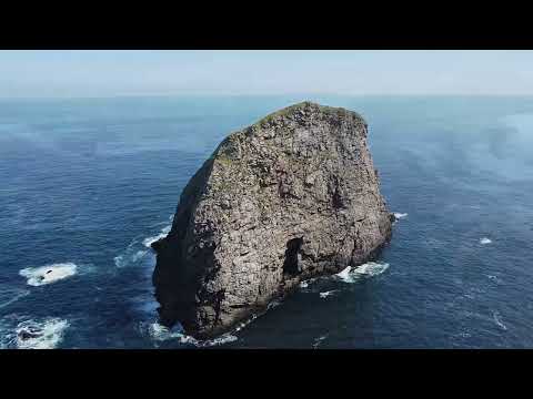
General Dún Briste
#4

Dún Briste

Dún Briste (Irish for 'broken fort') is a natural sea stack or pilaster – in geomorphology called a stack – off the western coast of Ireland in County Mayo. It consists of sedimentary strata that was deposited during the Carboniferous period, possibly Mississippian, approximately 350 million years ago.

Popularity
57
Explore place →
Quiet Man Museum — photo by N Chadwick #5

Quiet Man Museum

The Quiet Man Cottage Museum is a museum located in Cong, County Mayo, Ireland. It is a replica of the cottage used in John Ford's 1951 film The Quiet Man starring John Wayne, Maureen O'Hara and Barry Fitzgerald. It is typical of the Irish cottage of the 1820s featuring a thatched roof with an emerald green half door and whitewashed facade. The ground floor of the "'White-o-Morn' Cottage" has been reproduced as an identical replica of the original Hollywood film set. Much care was taken to accurately replicate the furnishings, artifacts and costumes on display. These items include the table and chairs, and four-poster bed, so appreciated by Mary Kate Danaher, the character played by Maureen O'Hara. The museum houses a large collection of newspaper cuttings from 1951 that recount what life was like when Hollywood descended on Cong. The costumes on display were made by the same company who made the original ones for the film: O'Maille's of Galway.

Popularity
37
Explore place →
Peak Mám Trasna
#6

Mám Trasna

Maumtrasna, historically Formnamore (Irish: Formna Mór, 'the great shoulder'), is the highest of the Partry Mountains in south County Mayo, Ireland, rising to 682 metres (2,238 ft) above sea level. The summit is broad and flat with several ridges running off it, including Skeltia (An Scoltach), Benwee (Binn Bhuí), Buckaun (An Bocán) and Binnaw (Binn Fheá). The peak of Knocklaur (Cnoc Láir, 'middle hill') stands on the ridge between Maumtrasna and Devilsmother mountains. The name 'Maumtrasna' comes from Mám Trasna, meaning "the pass across", and originally meant the hill pass on the road between Lough Nafooey and Lough Mask. The townland of Maumtrasna is on the south bank of the Srahnalong river. The townland was the location of the infamous Maumtrasna murders in 1882.

Popularity
36
Explore place →
National Museum of Ireland, Country Life — photo by Shanehahaha #7

National Museum of Ireland, Country Life

The National Museum of Ireland – Country Life, officially National Museum of Ireland, Turlough Park from 2026, is a branch of the National Museum of Ireland. Located near Turlough village, 8 km (5.0 mi) northeast of Castlebar, County Mayo, Ireland, and established in 2001, the museum is Ireland's only national museum outside Dublin. The museum exhibits the way of life of rural Irish people between 1850 and 1950, and is in the grounds of Turlough Park House. There are displays about the home, the natural environment, trades and crafts, communities, and working on the land and on water.

Popularity
33
Explore place →
Nephin Beg — photo by Sarah777 #8

Nephin Beg

Nephin Beg or Nefin Beg (Irish: Néifinn Bheag) is a mountain with a height of 627 metres (2,057 ft) in the Nephin Beg Range in County Mayo, Ireland. It is within Wild Nephin National Park. It seems to be named after the larger mountain Nephin (beag meaning 'little' or 'lesser'), although that mountain is some distance away and there are intervening mountains between them. Nephin Beg is also called Corr na gCapall, 'rounded/pointed mountain of the horse'.

Popularity
32
Explore place →
Uggool Beach — photo by Gordon Dunn #10

Uggool Beach

Uggool Beach (Irish: Trá an tOgúl) is a beach in County Mayo, on the west coast of Ireland, located south of the town of Louisburgh. It is situated at the mouth of Killary Harbour to its south, with Silver Strand to its north, Mweelrea mountain to its east and the Atlantic ocean to its west. Uggool Beach is bordered by the townlands of Uggool, Doovilra and Mweelin. The Bunanakee River flows across Uggool Beach. The tidal Dooneen Island is on the southern edge of the beach. Uggool Beach has been described as “stunningly beautiful” and “widely regarded as among the finest in Ireland”.

Popularity
29
Explore place →

Videos from Mayo

Conquering Croagh Patrick | An Epic Hiking Adventure Up Ireland's Holy Mountain

Conquering Croagh Patrick | An Epic Hiking Adventure Up Ireland's Holy Mountain

Travel With Wes

Croagh Patrick →
Our Lady of Knock: Ireland’s Silent Miracle #faith

Our Lady of Knock: Ireland’s Silent Miracle #faith

BellaagusDon

Knock Shrine →
Westport House Express, Ireland (4K)

Westport House Express, Ireland (4K)

Exploring Europe

Westport House →
WILD ATLANTIC WAY: Drone footage of Dún Briste, Downpatrick Head

WILD ATLANTIC WAY: Drone footage of Dún Briste, Downpatrick Head

Studio X

Dún Briste →
Benwee (An Bhinn Bhuí)

Benwee (An Bhinn Bhuí)

Ronan Mullarkey

An Bhinn Bhuí →
Aasleagh Falls (Eas Liath) - Hidden Waterfall in Connemara, Ireland 🇮🇪

Aasleagh Falls (Eas Liath) - Hidden Waterfall in Connemara, Ireland 🇮🇪

blackdeathvideos

Aasleagh Waterfall →

All places in Mayo

Showing 24 of 285 places

Croagh Patrick — photo by EamonnPKeane at English Wikipedia▶ Video
PeakMayo

Croagh Patrick

Croagh Patrick (Irish: Cruach Phádraig, meaning '(Saint) Patrick's stack'), nicknamed 'the Reek', is a mountain with a height of 764 m (2,507 ft) and an important site of pilgrimage in County Mayo, Ireland. The mountain has a pyramid-shaped peak and overlooks Clew Bay, rising above the village of Murrisk, several kilometres from Westport. It has long been seen as a holy mountain. It was the focus of a prehistoric ritual landscape, and later became associated with Saint Patrick, who is said to have spent forty days fasting on the summit. There has been a church on the summit since the 5th century; the current church dates to the early 20th century. Croagh Patrick is climbed by thousands of pilgrims every year on Reek Sunday, the last Sunday in July, a custom which goes back to at least the Middle Ages. Croagh Patrick is the fourth-highest mountain in the province of Connacht on the P600 listing after Mweelrea, Nephin and Barrclashcame. It is part of a longer east–west ridge; the lower westernmost peak is named Ben Goram.

Knock Shrine — photo by Paul Cowan▶ Video
GeneralMayo

Knock Shrine

The Sanctuary of Our Lady of Knock, commonly referred to as Knock Shrine, is a Roman Catholic pilgrimage site and national shrine in the village of Knock, County Mayo, Ireland, where locals claimed to have seen an apparition in 1879 of the Blessed Virgin Mary, Saint Joseph, Saint John the Evangelist, angels, and Jesus Christ (the Lamb of God).

Westport House — photo by Laurel Lodged▶ Video
CastleMayo

Westport House

Westport House in Westport, County Mayo, Ireland, is a Georgian country house, historically the family seat of the Marquess of Sligo and the Brownes. The house was designed by the architect Richard Cassels with later additions by Thomas Ivory and James Wyatt. The title and the house were separated in 2014, following the death of Jeremy Browne, 11th Marquess of Sligo, who left the estate to his five daughters. His titles passed to his first cousin, Sebastian Ulick Browne, a residential estate agent in Australia. In 2017, the house was purchased by the Hughes family, owners of Portwest.

GeneralDún Briste
▶ Video
GeneralMayo

Dún Briste

Dún Briste (Irish for 'broken fort') is a natural sea stack or pilaster – in geomorphology called a stack – off the western coast of Ireland in County Mayo. It consists of sedimentary strata that was deposited during the Carboniferous period, possibly Mississippian, approximately 350 million years ago.

Quiet Man Museum — photo by N Chadwick
MuseumMayo

Quiet Man Museum

The Quiet Man Cottage Museum is a museum located in Cong, County Mayo, Ireland. It is a replica of the cottage used in John Ford's 1951 film The Quiet Man starring John Wayne, Maureen O'Hara and Barry Fitzgerald. It is typical of the Irish cottage of the 1820s featuring a thatched roof with an emerald green half door and whitewashed facade. The ground floor of the "'White-o-Morn' Cottage" has been reproduced as an identical replica of the original Hollywood film set. Much care was taken to accurately replicate the furnishings, artifacts and costumes on display. These items include the table and chairs, and four-poster bed, so appreciated by Mary Kate Danaher, the character played by Maureen O'Hara. The museum houses a large collection of newspaper cuttings from 1951 that recount what life was like when Hollywood descended on Cong. The costumes on display were made by the same company who made the original ones for the film: O'Maille's of Galway.

PeakMám Trasna
PeakMayo

Mám Trasna

Maumtrasna, historically Formnamore (Irish: Formna Mór, 'the great shoulder'), is the highest of the Partry Mountains in south County Mayo, Ireland, rising to 682 metres (2,238 ft) above sea level. The summit is broad and flat with several ridges running off it, including Skeltia (An Scoltach), Benwee (Binn Bhuí), Buckaun (An Bocán) and Binnaw (Binn Fheá). The peak of Knocklaur (Cnoc Láir, 'middle hill') stands on the ridge between Maumtrasna and Devilsmother mountains. The name 'Maumtrasna' comes from Mám Trasna, meaning "the pass across", and originally meant the hill pass on the road between Lough Nafooey and Lough Mask. The townland of Maumtrasna is on the south bank of the Srahnalong river. The townland was the location of the infamous Maumtrasna murders in 1882.

National Museum of Ireland, Country Life — photo by Shanehahaha
MuseumMayo

National Museum of Ireland, Country Life

The National Museum of Ireland – Country Life, officially National Museum of Ireland, Turlough Park from 2026, is a branch of the National Museum of Ireland. Located near Turlough village, 8 km (5.0 mi) northeast of Castlebar, County Mayo, Ireland, and established in 2001, the museum is Ireland's only national museum outside Dublin. The museum exhibits the way of life of rural Irish people between 1850 and 1950, and is in the grounds of Turlough Park House. There are displays about the home, the natural environment, trades and crafts, communities, and working on the land and on water.

Nephin Beg — photo by Sarah777
PeakMayo

Nephin Beg

Nephin Beg or Nefin Beg (Irish: Néifinn Bheag) is a mountain with a height of 627 metres (2,057 ft) in the Nephin Beg Range in County Mayo, Ireland. It is within Wild Nephin National Park. It seems to be named after the larger mountain Nephin (beag meaning 'little' or 'lesser'), although that mountain is some distance away and there are intervening mountains between them. Nephin Beg is also called Corr na gCapall, 'rounded/pointed mountain of the horse'.

Rappa Castle — photo by Mike Searle
CastleMayo

Rappa Castle

Rappa Castle is a ruined castle located in Ballina, County Mayo, Ireland.

Uggool Beach — photo by Gordon Dunn
BeachMayo

Uggool Beach

Uggool Beach (Irish: Trá an tOgúl) is a beach in County Mayo, on the west coast of Ireland, located south of the town of Louisburgh. It is situated at the mouth of Killary Harbour to its south, with Silver Strand to its north, Mweelrea mountain to its east and the Atlantic ocean to its west. Uggool Beach is bordered by the townlands of Uggool, Doovilra and Mweelin. The Bunanakee River flows across Uggool Beach. The tidal Dooneen Island is on the southern edge of the beach. Uggool Beach has been described as “stunningly beautiful” and “widely regarded as among the finest in Ireland”.

Wild Nephin National Park — photo by Phil Armitage
National ParkMayo

Wild Nephin National Park

Wild Nephin (Irish: Néifinn Fhiáin, NAY-FINN) is a national park in northwest County Mayo, Ireland. It includes much of the Nephin Beg Mountains and one of the largest expanses of peatland in Europe, consisting of 150 square kilometres of Atlantic blanket bog. It is a unique habitat with a diverse flora and fauna. It was established as Ballycroy National Park in 1998, then expanded and re-named in 2018, with plans to re-wild the additional lands acquired at Nephin Forest to the east of the Nephin Beg Mountains. Wild Nephin includes the most remote point of land on the Irish mainland. The park is a candidate Special Area of Conservation (cSAC) as part of a site known as the Owenduff/Nephin Complex. It is also a Special Protection Area and part of the Natura 2000 network.

Mweelrea — photo by Britishfinance
PeakMayo

Mweelrea

Mweelrea (; from Irish Cnoc Maol Réidh 'bald hill with the smooth top') is a mountain on the Atlantic coast of County Mayo, Ireland. Rising to 814 metres (2,671 ft), it is the highest mountain in the western province of Connacht, and is noted for its southeastern cliff-lined corries, and its views. Mweelrea overlooks Killary Harbour and is at the heart of a "horseshoe-shaped" massif that includes the peaks of Ben Lugmore and Ben Bury. The massif is called the Mweelrea Mountains or the Mweelrea Range. Mweelrea is also the 26th-highest peak in Ireland on the Arderin list, and the 34th-highest on the Vandeleur-Lynam list.

Céide Fields — photo by Liz McCabe
Archaeological SiteMayo

Céide Fields

The Céide Fields (Irish: Achaidh Chéide, meaning 'flat-topped hill fields') is an extensive prehistoric archaeological landscape located on the north coast of County Mayo, Ireland. The complex consists of buried stone-walled field systems, habitation evidence, enclosures, and megalithic monuments preserved beneath blanket bog. The site has traditionally been interpreted as a Neolithic farming landscape dating to the fourth millennium BCE, based on radiocarbon dating, palaeoenvironmental analysis, excavation evidence, and long-term archaeological investigation conducted throughout the Céide Fields and wider North Mayo region. An alternative interpretation proposed by Andrew Whitefield has suggested that aspects of the landscape may be more comparable to later Bronze Age or Iron Age field systems documented elsewhere in Europe. The Behy court tomb, a megalithic monument, lies within the Céide Fields complex. The site is in UNESCO's tentative list to gain World Heritage status. There is estimated to be more than 100 km (62 mi) of field enclosure stone walls hidden beneath the peat bog.

Croaghaun — photo by Deejayw
PeakMayo

Croaghaun

Croaghaun (Irish: Cruachán) is a mountain on Achill Island in County Mayo, Ireland. At 688 metres (2,257 ft), it has the highest sea cliffs in Ireland, as well as the third-highest sea cliffs in Europe, after Hornelen, Norway, and Cape Enniberg, Faroe Islands.

Nephin — photo by Liz McCabe
PeakMayo

Nephin

Nephin (NAY-FINN) (Irish: Néifinn), at 806 metres (2,644 ft), is the highest standalone mountain in Ireland and the second-highest peak in Connacht (after Mweelrea). It is to the west of Lough Conn in County Mayo.

Corranabinnia — photo by Colin Park
PeakMayo

Corranabinnia

Corranabinnia (from Irish Coire na Binne, meaning 'hollow of the peak') is a mountain with a height of 716 metres (2,349 ft) in County Mayo, Ireland. It is also known as Cushcamcarragh (from Irish Coiscéim Charrach, meaning 'rocky step') and is part of the Nephin Beg Range. It has several spurs, including Bengorm to the east. The mountain overlooks several corries and glens, including Corranabinnia Lough (west), Corryloughaphuill (north), Glennamong (east), Glendahurk (southeast), Glenthomas (southwest).

Slievemore — photo by Turkishbob at English Wikipedia
PeakMayo

Slievemore

Slievemore (Irish: Sliabh Mór, meaning 'big mountain') is the second highest peak on Achill Island after Croaghaun, in County Mayo, Ireland. Its elevation is 671 m (2,201 ft).

Ben Gorm — photo by Keith Salvesen
PeakMayo

Ben Gorm

Ben Gorm (Irish: An Bhinn Ghorm, meaning 'the blue peak') is a mountain with a height of 700 metres (2,300 ft) on the north side of Killary Harbour in County Mayo, Ireland. The Ben Gorm mountains also includes two other peaks: Ben Creggan/Binn an Charragáin (693 m), and Maul Laur/Meall Láir or Ben Creggan South Top (687 m). The Ben Gorm group overlooks Killary Harbour to the south, Fin Lough and Doo Lough to the west (which separate it from the Mweelrea Mountains), Glenummera to the north (which separate it from the Sheeffry Hills), and Glendavock to the east.

Barrclashcame — photo by Colin Park
PeakMayo

Barrclashcame

Barrclashcame (from Irish Barr Chlais Céim, meaning 'top of Clais Céim') is a mountain with a height of 772 metres (2,533 ft) in the Sheeffry Hills of County Mayo, Ireland.

Birreencorragh — photo by Colin Park
PeakMayo

Birreencorragh

Birreencorragh is a mountain in the Nephin Beg Range, County Mayo, Ireland, reaching 698 metres (2,290 ft) above sea level.

Clew Bay Heritage Centre — photo by Colin Park
MuseumMayo

Clew Bay Heritage Centre

Clew Bay Heritage Centre is a local history museum in Westport, County Mayo, Ireland. Located in the west of the town, on the pier, it illustrates the social history and heritage of the Clew Bay area and Westport. Topics covered include Croagh Patrick, Grace O'Malley, John MacBride, Maud Gonne, the Irish War of Independence, the 1798 Rebellion and schooling in the area. The museum is located in a 19th-century stone building, once used for holding live pigs prior to transport, donated by the Harbour Board. It was founded by Westport Historical Society in 1987. Tour guides describe it as "a chaotic but engaging jumble" and "a veritable garage sale of history."

Shrule Abbey — photo by Bmcgeene
Archaeological SiteMayo

Shrule Abbey

Shrule Abbey is a former monastery and National Monument located in County Mayo, Ireland.

Slieve Carr — photo by Michael Earnshaw
PeakMayo

Slieve Carr

Slieve Carr, also known as Slieve Cor or Corslieve (Irish: Corrshliabh, meaning 'conspicuous mountain'), is a mountain with a height of 721 metres (2,365 ft) in County Mayo, Ireland. It is part of the Nephin Range and is beside Nephin Beg. The mountain is in Wild Nephin National Park and it is the most remote point of land on the Irish mainland. Slieve Carr is a long mountain running north–south, with several small lakes on its eastern slopes. On the summit is a burial cairn known as Laghtdauhybaun, from Leacht Dáithí Bháin, 'burial monument of white Dáithí'. This is believed to refer to Dathí, a king of Connacht in the 5th century.

More counties in Connacht